Bike Lane on Temescal
Regarding your August 17 story (“Eliminating Car Lane on Temescal Not Holzer’s Idea”), safety is a goal that involves efficient traffic flow. Alternative means of transportation, such as biking, benefit us all. If the bike lane on Temescal Canyon Road can be justified, why not take a bit out of the park, not the road? No one uses that downhill side anyway.
Trish Sobul
Gateway Project Has Temescal Concerns
(The following letter was sent Aug. 6 to Jessie Holtzer, Councilman Mike Bonin’s Mobility Deputy, regarding the contemplated bike lane on Temescal Canyon Road.)
I was delighted to see that you, the Council office, and LADOT are taking a look at Temescal Canyon Road (articles last week in the Palisades News and Palisadian-Post). From what I read, your focus at this point is primarily on a bike lane to extend the City’s bike network.
I would like to encourage you to expand your scope to include overall pedestrian, bike, bus and traffic safety on Temescal, particularly with respect to Palisades Charter High School.
The school’s students, faculty, staff, families and visitors are by far the primary users and stakeholders who would be impacted by any changes to Temescal Canyon Road. And positive changes are much needed.
For several years, the school and a dedicated group of volunteers called the Pali Gateway Committee have been making safety and aesthetic improvements and proposals for the front door of the school along Bowdoin, and in particular at the intersection of Bowdoin and Temescal.
As a Pali parent, I have been helping to lead the design side of the effort. The project has garnered wide support within the school community and alumni, and in the Palisades community at large.
The Bowdoin-Temescal intersection is one of the most heavily used, and often most chaotic, in all of Pacific Palisades. We have ongoing and serious concerns about the safety of our students and school community who cross at Temescal by the thousands each week. I believe the intersection has a significant record of accidents.
I want to suggest that the primary focus for any restriping or reconfiguration of Temescal should be the numerous safety issues in the vicinity of the Bowdoin intersection: pedestrian congestion, crosswalk design, bus movements, signalization, left turns, U-turns, and speeding among others, particularly during morning drop-off and afternoon pick-up. This would certainly accord with the city, LADOT and Councilman Bonin’s Vision Zero plan to improve street safety for both cyclists and pedestrians.
No doubt a bike lane should be part of that consideration, particularly to the extent that it can calm traffic and improve safety for all users. But any consideration of bike users (who are primarily recreational and mainly there on weekends) must also address the much more widespread, persistent and everyday threats to pedestrian safety at Temescal and Bowdoin.
I believe that during your community meetings, Pacific Palisades Community Council Area 4 Representative Rick Mills encouraged you to speak with Palisades High to open up a conversation with the school about the potential redesign of Temescal Canyon Road. In fact, this is a conversation that the Pali Gateway Committee has been hoping to initiate with the Council office for some time, so your proposal provides a perfect opportunity to do so.
Doug Suisman
Senior Beach Passes Available
An annual County Beach Pass for L.A. County beaches, including Will Rogers Beach at PCH and Temescal, is available for $25 for seniors. You can purchase one by mail or in person. Your car registration and $25 is required. The beach must have an attendant who will read the pass to allow the driver to enter the lot. A list and map of all eligible beaches is provided with T&Cs and hours for their use. Contact: L.A. County Dept. of Beaches and Harbors, 14110 Palawan Way, Marina Del Rey. Call (310) 821-1081 or visit: beaches.lacounty.gov.
Karen Ridgley
Speak Up for the Trees
Based on the letter the Palisades News published in its last edition (“Ficus Trees and Hearing”), I followed up with a strong email to the individuals named in the letter (Tim Tyson in Urban Forestry and Public Work’s Ron Lorenzen ron.lorenzen@lacity.org), clearly stating my opposition to the cutting down of trees on Sunset and Swarthmore in order to build an underground parking lot.
I received a quick response from Tim (tim.tyson @lacity.org) stating that there will be a hearing, regarding cutting the trees, but it may not be for 60 days. I trust the Palisades News will announce the meeting to the community. It would be great if we can get the project scaled back to save some or all of the trees, especially the large ficus by the Mobil station. Please encourage those not able to attend the meeting to send emails to the two named in the letter as it was certainly effective.
Gina Ladinsky
India: Fabulous and Funny
Having just returned from a shorter trip to India than Pepper and Joe Edmiston took, I’d have to say Pepper nailed it in her article in the News (“India: Chaos, Color and Cholera,” July 6).
Our trip was the Golden Triangle: Delhi, Agra and Jaipur. The country is amazing, the food terrific and we stayed in 4- and 5-star hotels. All our destinations had fantastic public monuments, temples, mosques and forts, and of course we visited the Taj Mahal. We saw fantastic animals, though not in a national park. In Delhi we mostly saw cows, cats and dogs but in Jaipur—on the streets, on the roads, tethered or loose—there were cows and camels, donkeys and horses, monkeys and dogs, cats and goats.
On the freeway from Jaipur back to Delhi, we stopped for a wedding party crossing the freeway, a funeral party crossing the freeway and a herd of about 60 goats, with the goat herder. On the two-lane surface streets, everybody vied for the narrow space—cars, tuk tuks, motorcycles, bikes, trucks, an occasional cow, children selling balloons, pedestrians and oncoming traffic. Intersections defied physics.
One day in Delhi, in an 11-hour span, we spent five hours at monuments and six hours in traffic.
All in all, a stunning country where one-fifth of the world’s population lives. Lots of problems and lots of beauty.
Alice Clement
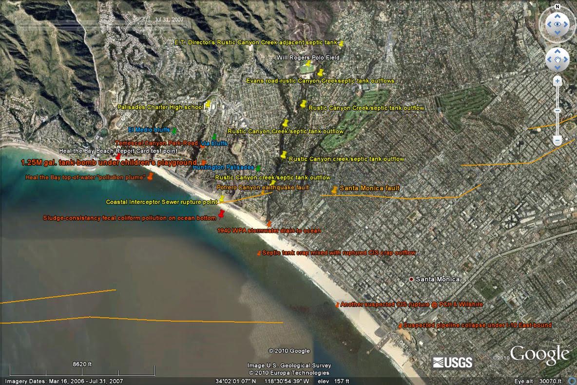
Why Potrero Is Not Completed
I have the true reason the city has taken “close to 30 years” filling Potrero Canyon and creating a park. The city’s former Principal Sanitary Engineer (circa 1990), now the city engineer, had prior knowledge that Potrero Canyon is on a surface level earthquake fault (actually 4 meters deep) discovered by C. F. Richter and his team in 1930, as documented in his report in that year, “The Earthquake in the Santa Monica Bay.”
The “slope failure at 211 Alma Real” was because that home sits exactly over the earthquake fault. A Google Earth satellite shot taken July 31, 2007 shows the Potrero Canyon fault (indicated by an orange line courtesy of a Caltech/USGS earthquake fault overlay software program).

So why has the Bureau of Engineering dragged its feet almost 30 years? Because this satellite shot clearly shows that the 1924 Coastal Interceptor Sewer (CIS) that runs under PCH was severed during the Northridge quake in 1994. And that even 13 years later the city had not repaired it, even though the City of L.A. received federal funds to do so.
This photograph also shows the reason for the (continuing) fecal coliform pollution in Santa Monica Bay. The CIS, with its hundreds of micro-cracks caused by over 150 tremors of 3.5 or greater since Northridge, has allowed the fecal coliform to travel via capillary action under the sand and directly into the bay.
This shot also proves what the Palisadian-Post wrote about six years ago that fecal coliform (broken down human feces) acts the same way in the ocean as it does in a septic tank: scum layer on top (to the left), clear in the middle, and sludge layer on the bottom (the brown seen resting on the ocean floor under the orange line). This is what the city engineer has been afraid of all these years, but the public is unaware. I discovered this deception six years ago while researching the non-viability of the Temescal Canyon Park Stormwater Diversion Project.
Patrick Hart
Palisades News welcomes all letters, which may be emailed to letters@palisadesnews.com. Please include a name, address and telephone number so we may reach you. Letters do not necessarily reflect the viewpoint of the Palisades News.


You must be logged in to post a comment.