An evacuation center at Westwood Recreation Center, located at 1350 S Sepulveda Blvd., is open for evacuees and accepts small animals
By Zach Armstrong
5th Update:
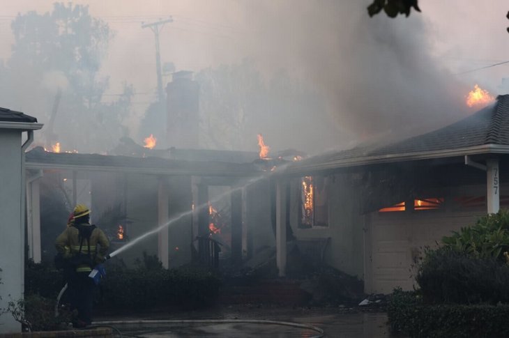
The ravenous Palisades fire that started yesterday morning has now grown to encompass 15,832 Acres and has destroyed at least 1,000 homes, businesses and other establishments, marking its place in LA history as the most destructive to ever hit the region.
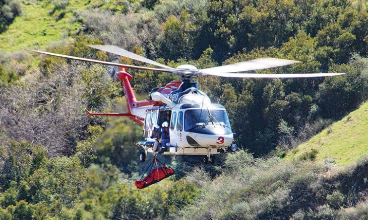
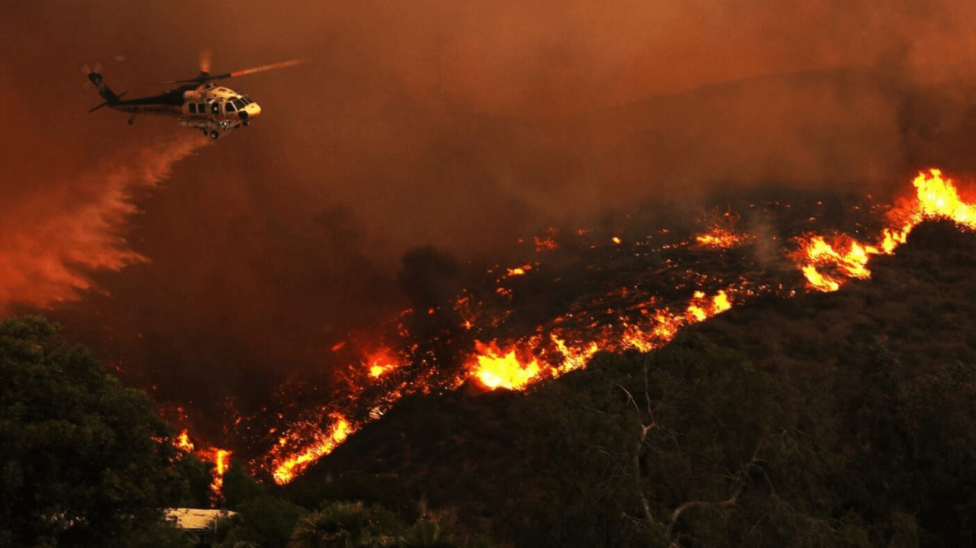
By 2:45PM, LAFD reported that the fire was not contained at all. A dozen helicopters and three fixed wing aircraft across multiple agencies were working to battle the flames, with earlier reports stating that hundreds of firefighters were deployed in the effort.
The neighborhood has been under urgent evacuation after a rapidly-spreading brush fire that ignited Tuesday morning near Piedra Morada Drive. The area of Palisades under evacuation orders is from north to Mulholland Road, east to Kenter Rd and south to PCH. The City of Santa Monica expanded its evacuation order Wednesday afternoon for all areas north of Montana Avenue from the beach to 11th Street.
Five fatalities have been reported amid the devastating wildfires that currently grip LA County, but none of them occurred within the Palisades.
A video posted on X by @JonVigliotti showed the Palisades Village area as a skeletal ember of its former self.
Everything around the intersection of Antioch and Swarthmore is nearly or completely incinerated. The Starbucks at 15300 Sunset Blvd. along with adjacent businesses on its same block, as well as the entire stretch of businesses along Antioch in between Swarthmore and Via de la Paz, is simply gone. The stretch of businesses along N Swarthmore from Antioch down to La Cruz Drive appear to have vanished in flames as well. The video showed Palm Trees completely blackened and shedding their leaves.
At the time of this writing, the fire has also been reported to have partly damaged or entirely destroyed Palisades Charter High School and Elementary School, the PCH-adjacent seafood restaurant Reel Inn, while the Getty Villa Museum confirmed to outlets that its grounds had caught fire.
A high wind warning is in effect until 6 p.m. tonight, as projections are calling for north to northeast winds 25 – 40 mph with gusts between 60 – 80 mph.
An evacuation center at Westwood Recreation Center, located at 1350 S Sepulveda Blvd., is open for evacuees and accepts small animals. Those outside the evacuation area are asked to shelter in place. Pierce College, located at 6201 Winnetka Ave., is open for the evacuation of large animals.
4th Update:
The Getty Villa Museum, Palisades Charter High School and seafood restaurant The Reel Inn have become victims of the Palisades fire– now reported as scorching nearly 3,000 acres.
Reports from Fox 11 showed the high school’s campus ravaged by flames including the baseball field and tennis courts. About an hour before, the Getty Villa confirmed with the LA Times that its grounds were burning, while noting recent efforts to clear brush from the surrounding area as part of fire mitigation efforts. “Some trees and vegetation on site have burned, but staff and the collection remain safe.” an official statement read. Owners of The Reel Inn– whose towering sign was seen engulfed in flames in a recent online video –wrote in a social media post that they are“grateful for the 36 years we’ve been a part of the community. Grateful to all of our customers. We are heartbroken and unsure what will be left,”
The recent developments come as even more intense winds responsible for the devastating fire are expected overnight, with the flames spreading like mad just hours after being first reported. Whereas just 200 acres were ablaze this morning, the fire’s radius now encompasses 2,921 acres, according to CalFire.
The neighborhood is under an urgent evacuation order after a rapidly-spreading brush fire that ignited Tuesday morning near Piedra Morada Drive. By 7:30 p.m., the evacuation zone expanded east to Kenter and north to Mulholland Rd. in addition to Merrimac Road from the northeast, Topanga Canyon Boulevard from the northwest, and the Pacific Coast Highway from the south.
About 30,000 residents from 10,000 homes have been evacuated so far, the LA Times reported.
“The fire is being fueled by a combination of strong winds and surrounding topography, which is making it extremely challenging for our personnel that are assigned to this incident,” Los Angeles Fire Department Chief Kristin Crowley told The Los Angeles Times.
Wind gusts are expected to peak between 10 p.m. Tuesday and 5 a.m. Wednesday, according to the National Weather Service.
Exact locations of impacted homes are not known at this time, although videos and photos posted across social media and news outlets have shown Palisadian houses scorching with orange glow, including a residence on Bollinger Drive photographed by Wally Skalij.
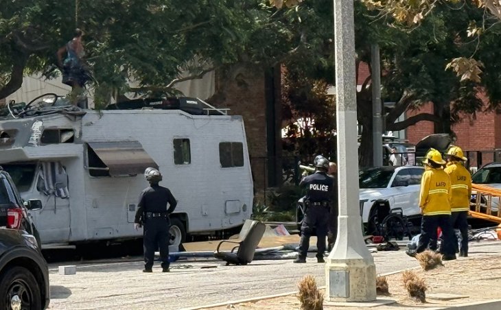
Just before 2: 30 p.m., LAFD issued an update that over 250 LAFD firefighters including from neighboring agencies were battling the flames, while approximately 30 vehicles were left abandoned on Sunset and Palisades. Those cars will be moved by the County dozer to provide clear access.
An evacuation center at Westwood Recreation Center, located at 1350 S Sepulveda Blvd., is open for evacuees and accepts small animals. Those outside the evacuation area are asked to shelter in place. Pierce College, located at 6201 Winnetka Ave., is open for the evacuation of large animals.
Capt. Michael McIndoe of LAFD Station 69 told Mirror Media Group yesterday he expected augmented staffing (extra dispatch patrols and helicopters) to be provided for Palisades and other at-risk areas on Tuesday, along with the enforcement of red flag parking to ensure residents can easily exit their homes. McIndoe also encouraged residents to check out LAFD’s “Ready, Set, Go!” program to learn more about evacuation preparedness, and download the Watch Duty app to get alerts about nearby wildfires and firefighting efforts.
Several factors put Palisades in particular danger. Much of the region is covered in flammable vegetation and brush, including dense chaparral which, especially if dry and in areas that haven’t burned in years, can result in intense fires. Once ignited, the area’s steep terrain can cause fires to spread quickly uphill, making containment difficult.
A 2022 report from the nonprofit First Street Foundation identified over 9,000 Palisadian properties — 99% of all properties in the neighborhood — as being at risk for wildfire damage over the next three decades. All of Palisades is included in the LAFD’s Very High Fire Hazard Severity Zone along with other mountainous regions such as Brentwood, Westwood and Bel Air Estates.For an interactive evacuation map and current status of the fire, go to https://lafd.org/news/palisades-fire-0.
3rd Update:
The winds responsible for the devastating Palisades fire are set to intensify overnight, as the flames have grown to 1,261 acres and are heading west, LAFD announced.
The neighborhood is under an evacuation order after a rapidly-spreading brush fire that ignited Tuesday morning near Piedra Morada Drive. Initial reports had the flames’ radius at 200 acres. By 3:30 p.m., that number had grown six-fold. About 30,000 residents from 10,000 homes have been evacuated so far, the Los Angeles Times reported.
“The fire is being fueled by a combination of strong winds and surrounding topography, which is making it extremely challenging for our personnel that are assigned to this incident,” Los Angeles Fire Department Chief Kristin Crowley told The Los Angeles Times.
Wind gusts are expected to peak between 10 p.m. Tuesday and 5 a.m. Wednesday, according to the National Weather Service.
Exact locations of impacted homes are not known at this time, although videos and photos posted across social media and news outlets have shown Palisadian houses scorching with orange glow, including a residence on Bollinger Drive photographed by Wally Skalij.
Just before 2: 30 p.m., LAFD issued an update that over 250 LAFD firefighters including from neighboring agencies were battling the flames, while approximately 30 vehicles were left abandoned on Sunset and Palisades. Those cars will be moved by the County dozer to provide clear access.
The area under evacuation goes from Merrimac Road from the northeast, Topanga Canyon Boulevard from the northwest, and the Pacific Coast Highway from the south.
An evacuation center at Westwood Recreation Center, located at 1350 S Sepulveda Blvd., is open for evacuees and accepts small animals. Those outside the evacuation area are asked to shelter in place. Pierce College, located at 6201 Winnetka Ave., is open for the evacuation of large animals.
Capt. Michael McIndoe of LAFD Station 69 told Mirror Media Group yesterday he expected augmented staffing (extra dispatch patrols and helicopters) to be provided for Palisades and other at-risk areas on Tuesday, along with the enforcement of red flag parking to ensure residents can easily exit their homes. McIndoe also encouraged residents to check out LAFD’s “Ready, Set, Go!” program to learn more about evacuation preparedness, and download the Watch Duty app to get alerts about nearby wildfires and firefighting efforts.
Several factors put Palisades in particular danger. Much of the region is covered in flammable vegetation and brush, including dense chaparral which, especially if dry and in areas that haven’t burned in years, can result in intense fires. Once ignited, the area’s steep terrain can cause fires to spread quickly uphill, making containment difficult.
A 2022 report from the nonprofit First Street Foundation identified over 9,000 Palisadian properties — 99% of all properties in the neighborhood — as being at risk for wildfire damage over the next three decades. All of Palisades is included in the LAFD’s Very High Fire Hazard Severity Zone along with other mountainous regions such as Brentwood, Westwood and Bel Air Estates.
For an interactive evacuation map and current status of the fire, go to https://lafd.org/news/palisades-fire-0.
2nd Update:
The Palisades fire now covers 770 acres while over 250 LAFD firefighters including from neighboring agencies battle the flames, LAPD announced just before 2:30 p.m.
Approximately 30 vehicles have been left abandoned on Sunset and Palisades. These will be moved by the County dozer to provide clear access, LAFD announced.
Most of the Pacific Palisades is under an evacuation order after a rapidly-spreading brush fire that ignited Tuesday morning near Piedra Morada Drive grew to almost a thousand acres, posing an immediate threat to homes in the area, according to LAFD.
The area under evacuation goes from Merrimac Road from the northeast, Topanga Canyon Boulevard from the northwest, and the Pacific Coast Highway from the south. An evacuation center at Westwood Recreation Center, located at 1350 S Sepulveda Blvd., is open for evacuees and accepts small animals. Those outside the evacuation area are asked to shelter in place.
Sunset Boulevard is reported as being congested with traffic as residents rush to flee the area, while Eastbound Pacific Coast Highway is closed at Topanga Canyon Boulevard due to that brush fire. Residents are asked to take alternative routes if possible.
Honorary Mayor of the Pacific Palisades Eugene Levy evacuated his home, telling The Los Angeles Times that “The smoke looked pretty black and intense over Temescal Canyon. I couldn’t see any flames but the smoke was very dark.”
A video posted around Noon on Instagram by SBRBN Los Angeles showed Palisadian homes already being caught in the fiery flames. Exact locations of impacted homes are not known at this time.
Capt. Michael McIndoe of LAFD Station 69 told Mirror Media Group yesterday he expected augmented staffing (extra dispatch patrols and helicopters) to be provided for Palisades and other at-risk areas on Tuesday, along with the enforcement of red flag parking to ensure residents can easily exit their homes. McIndoe also encouraged residents to check out LAFD’s “Ready, Set, Go!” program to learn more about evacuation preparedness, and download the Watch Duty app to get alerts about nearby wildfires and firefighting efforts.
Several factors put Palisades in particular danger. Much of the region is covered in flammable vegetation and brush, including dense chaparral which, especially if dry and in areas that haven’t burned in years, can result in intense fires. Once ignited, the area’s steep terrain can cause fires to spread quickly uphill, making containment difficult.
A 2022 report from the nonprofit First Street Foundation identified over 9,000 Palisadian properties — 99% of all properties in the neighborhood — as being at risk for wildfire damage over the next three decades. All of Palisades is included in the LAFD’s Very High Fire Hazard Severity Zone along with other mountainous regions such as Brentwood, Westwood and Bel Air Estates.For an interactive evacuation map and current status of the fire, go to https://lafd.org/news/palisades-fire-0.
Most of the Pacific Palisades is under an evacuation order after a rapidly-spreading brush fire that ignited Tuesday morning near Piedra Morada Drive grew to 200 acres, posing an immediate threat to homes in the area, according to LAFD.
The area under evacuation goes from Merrimac Road from the northeast, Topanga Canyon Boulevard from the northwest, and the Pacific Coast Highway from the south. An evacuation center at Westwood Recreation Center, located at 1350 S Sepulveda Blvd., is open for evacuees and accepts small animals. Those outside the evacuation area are asked to shelter in place.
Sunset Boulevard is reported as being congested with traffic as residents rush to flee the area, while Eastbound Pacific Coast Highway is closed at Topanga Canyon Boulevard due to that brush fire. Residents are asked to take alternative routes if possible.
Honorary Mayor of the Pacific Palisades Eugene Levy evacuated his home, telling The Los Angeles Times that “The smoke looked pretty black and intense over Temescal Canyon. I couldn’t see any flames but the smoke was very dark.”
A video posted around Noon on Instagram by SBRBN Los Angeles showed Palisadian homes already being caught in the fiery flames. Exact locations of impacted homes are not known at this time.
Capt. Michael McIndoe of LAFD Station 69 told Mirror Media Group yesterday he expected augmented staffing (extra dispatch patrols and helicopters) to be provided for Palisades and other at-risk areas on Tuesday, along with the enforcement of red flag parking to ensure residents can easily exit their homes. McIndoe also encouraged residents to check out LAFD’s “Ready, Set, Go!” program to learn more about evacuation preparedness, and download the Watch Duty app to get alerts about nearby wildfires and firefighting efforts.
Several factors put Palisades in particular danger. Much of the region is covered in flammable vegetation and brush, including dense chaparral which, especially if dry and in areas that haven’t burned in years, can result in intense fires. Once ignited, the area’s steep terrain can cause fires to spread quickly uphill, making containment difficult.
A 2022 report from the nonprofit First Street Foundation identified over 9,000 Palisadian properties — 99% of all properties in the neighborhood — as being at risk for wildfire damage over the next three decades. All of Palisades is included in the LAFD’s Very High Fire Hazard Severity Zone along with other mountainous regions such as Brentwood, Westwood and Bel Air Estates.For an interactive evacuation map and current status of the fire, go to https://lafd.org/news/palisades-fire-0.